close
Trail Conditions
- Unknown
- Snow Groomed
- Snow Packed
- Snow Covered
- Snow Cover Inadequate
- Freeze/thaw Cycle
- Icy
- Prevalent Mud
- Wet
- Variable
- Ideal
- Dry
- Very Dry
Trail Flow (Ridden Direction)
Trailforks scans users ridelogs to determine the most popular direction each trail is ridden. A good flowing trail network will have most trails flowing in a single direction according to their intension.
The colour categories are based on what percentage of riders are riding a trail in its intended direction.
The colour categories are based on what percentage of riders are riding a trail in its intended direction.
- > 96%
- > 90%
- > 80%
- > 70%
- > 50%
- < 50%
- bi-directional trail
- no data
Trail Last Ridden
Trailforks scans ridelogs to determine the last time a trail was ridden.
- < 2 days
- < 1 week
- < 2 weeks
- < 1 month
- < 6 months
- > 6 months
Trail Ridden Direction
The intended direction a trail should be ridden.
- Downhill Only
- Downhill Primary
- Both Directions
- Uphill Primary
- Uphill Only
- One Direction
Contribute Details
Colors indicate trail is missing specified detail.
- Description
- Photos
- Description & Photos
- Videos
Trail Popularity ?
Trailforks scans ridelogs to determine which trails are ridden the most in the last 9 months.
Trails are compared with nearby trails in the same city region with a possible 25 colour shades.
Think of this as a heatmap, more rides = more kinetic energy = warmer colors.
- most popular
- popular
- less popular
- not popular
ATV/ORV/OHV Filter
Max Vehicle Width
inches
Radar Time
x
Activity Recordings
Trailforks users anonymized public ridelogs from the past 6 months.
- mountain biking recent
- mountain biking (>6 month)
- hiking (1 year)
- moto (1 year)
Activity Recordings
Trailforks users anonymized public skilogs from the past 12 months.
- Downhill Ski
- Backcountry Ski
- Nordic Ski
Jump Magnitude Heatmap
Heatmap of where riders jump on trails. Zoom in to see individual jumps, click circles to view jump details.
Trails Deemphasized
Trails are shown in grey.
Only show trails with NO bikes.
Save the current map location and zoom level as your default home location whenever this page is loaded.
Save
No description for Pedro Mountain has been added yet!
Login or register to submit one.
 google parking directions
google parking directions Activities Click to view
- Mountain Bike
19 trails
- Hike
18 trails
- Trail Running
18 trails
Region Details
- 3
- 1
- 1
- 7
- 4
- 2
- 1
Region Status
Open as of Feb 12, 2022Stats
- Avg Trail Rating
- Trails (view details)
- 22
- Trails Mountain Bike
- 19
- Trails E-Bike
- 6
- Trails Hike
- 18
- Trails Trail Running
- 18
- Trails Horse
- 2
- Total Distance
- 21 miles
- Total Descent Distance
- 11 miles
- Total Descent
- 5,688 ft
- Total Vertical
- 1,808 ft
- Highest Trailhead
- 1,890 ft
- Reports
- 807
- Photos
- 278
- Ridden Counter
- 12,095
Popular Pedro Mountain Mountain Biking Trails
Pedro Mountain Mountain Bike Routes
| title | rating | distance |
|---|---|---|
| Brian Gong's Leisure Lap | 10 miles | |
| Best of the Bay Area Bike Packing Adventure | 166 miles | |
| Montara Boy Scout Loop | 9 miles | |
| Pedro Point Headlands | 4 miles | |
| 15 mile Pedro Mountain Ride | popular ridelog | 15 miles |
| 13 mile Pedro Mountain Cross-country Ride | popular ridelog | 13 miles |
| 12 mile Pedro Mountain Ride | popular ridelog | 12 miles |
| 9 mile Pedro Mountain Ride | popular ridelog | 9 miles |
| 9 mile Pedro Mountain Ride | popular ridelog | 9 miles |
| 14 mile Pedro Mountain Cross-country Ride | popular ridelog | 14 miles |
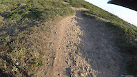
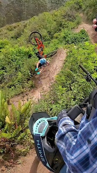
Photos of Pedro Mountain Mountain Bike
trail: Boy Scout Trail
27 |
Jun 5, 2022 @ 8:19am
Jun 5, 2022
trail: Boy Scout Trail
18 |
Jun 5, 2022 @ 8:19am
Jun 5, 2022
trail: Two Pines
52 |
Mar 19, 2022 @ 8:28am
Mar 19, 2022
trail: Green Valley Trail
19 |
Mar 19, 2022 @ 8:28am
Mar 19, 2022
trail: Green Valley Trail
14 |
Mar 19, 2022 @ 8:28am
Mar 19, 2022
trail: Green Valley Trail
13 |
Mar 19, 2022 @ 8:28am
Mar 19, 2022
trail: San Pedro Mountain Crest
250 |
Aug 29, 2020 @ 5:22pm
Aug 29, 2020
trail: San Pedro Mountain Crest
309 |
Jul 2, 2020 @ 6:38pm
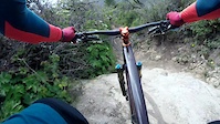
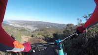
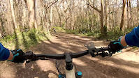
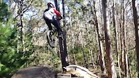
Jul 2, 2020Videos of Pedro Mountain Mountain Bike
trail: Mile
35 |
Jun 23, 2022
trail: Mile
102 |
May 16, 2022
trail: Crack
102 |
May 8, 2022

trail: Tanga
40 |
Dec 27, 2021
trail: Mile
110 |
Dec 9, 2021
trail: Pedro Mountain Rd (Trail)
607 |
Jun 5, 2021
trail: Boy Scout Trail
175 |
Apr 28, 2021
trail: Boy Scout Trail
330 |
Feb 1, 2021
Current Trail Warnings
| status | trail | date | condition | user | info |
|---|---|---|---|---|---|
| Mile | Jun 21, 2022 @ 10:14am Jun 21, 2022 | Very Dry | Ericofg | deep ruts |
Recent Trail Reports
| status | trail | date | condition | info | user |
|---|---|---|---|---|---|
| San Pedro Mountain Crest | Jul 5, 2022 @ 6:00pm 8 hours | Ideal | Bro-tato | ||
| Old Colma Road | Jul 5, 2022 @ 6:00pm 8 hours | Ideal | Bro-tato | ||
| Old Colma Road | Jul 5, 2022 @ 6:00pm 8 hours | Ideal | Bro-tato | ||
| Gray Whale Cove Trail | Jul 2, 2022 @ 8:06am Jul 2, 2022 | Wet | Baunty | ||
| North Peak Access Road | Jul 2, 2022 @ 8:06am Jul 2, 2022 | Wet | Baunty | ||
| Nick's revenge | Jul 2, 2022 @ 8:06am Jul 2, 2022 | Wet | Baunty | ||
| Fly Amanita | Jul 2, 2022 @ 8:06am Jul 2, 2022 | Wet | Baunty | ||
| Lower Fly Amanita | Jul 2, 2022 @ 8:06am Jul 2, 2022 | Wet | Baunty | ||
| Green Valley Trail | Jun 21, 2022 @ 10:14am Jun 21, 2022 | Dry | Ericofg | ||
| Crack | Jun 20, 2022 @ 8:19pm Jun 20, 2022 | Dry | ACM1234 |
Activity Feed
| username | action | type | title | date | |
|---|---|---|---|---|---|
 | Bro-tato | add | report | San Pedro Mountain Crest and 2 more | Jul 5, 2022 @ 9:07pm 5 hours |
 | angrychicken | vote | trail | Mile | Jul 5, 2022 @ 5:14pm 9 hours |
 | johenkai | wishlist | route | Brian Gong's Leisure Lap | Jul 3, 2022 @ 12:37pm 3 days |
 | Baunty | add | report | Gray Whale Cove Trail and 4 more | Jul 2, 2022 @ 12:42pm Jul 2, 2022 |
| semisafesends | vote | trail | Crack | Jul 1, 2022 @ 3:34pm Jul 1, 2022 |
Recent Comments
| username | type | title | comment | date | |
|---|---|---|---|---|---|
| trail | I'm pretty sure the majority of the people go... | Jun 29, 2022 @ 11:57am Jun 29, 2022 | ||
 | trail | This is an uphill climbing trail. Please... | Jun 18, 2022 @ 10:33pm Jun 18, 2022 | ||
| trail | The drop at the end of the rock garden gets... | Jun 10, 2022 @ 9:11pm Jun 10, 2022 | ||
| trail | Steep switchbacks, deep ruts. Great views on... | Jun 10, 2022 @ 9:08pm Jun 10, 2022 | ||
| trail | This is a beautiful trail to climb, with a few... | Nov 13, 2021 @ 8:31am Nov 13, 2021 |
Nearby Areas
| name | distance | ||||
|---|---|---|---|---|---|
| Pedro Mountain | 2.5 km | ||||
| El Granada | 1 | 4 | 2 | 5.1 km | |
| Highlands | 1 | 2 | 3 | 9.4 km | |
| Lake Merced Park | 9.8 km | ||||
| McLaren Park | 1 | 10.5 km |
Activity Type Stats
| activitytype | trails | distance | descent | descent distance | total vertical | rating | global rank | state rank | photos | reports | routes | ridelogs |
|---|---|---|---|---|---|---|---|---|---|---|---|---|
| Mountain Bike | 19 | 18 miles | 5,128 ft | 10 miles | 1,808 ft | #552 | #286 | 264 | 807 | 4 | 10,540 | |
| E-Bike | 6 | 12 miles | 1,739 ft | 5 miles | 1,808 ft | 711 | 1 | 881 | ||||
| Hike | 18 | 19 miles | 4,101 ft | 9 miles | 1,808 ft | #463 | #285 | 14 | 783 | 1 | 422 | |
| Trail Running | 18 | 19 miles | 4,101 ft | 9 miles | 1,808 ft | #462 | #282 | 783 | 1 | 128 | ||
| Horse | 2 | 2 miles | 505 ft | 1 mile | 735 ft | 26 |
- By brenthillier
 NSMBA TRAILFORKS & contributors
 - Admins: banq
- #3928 - 9,909 views
- pedro mountain activity log | embed map of Pedro Mountain mountain bike trails | pedro mountain mountain biking points of interest
Downloading of trail gps tracks in kml & gpx formats is enabled for Pedro Mountain.
You must login to download files.