Supporters, Builders, Maintainers & Land Managers of Flow 1 Trail

Bell Bike HelmetsSponsor
Specialized Bicycle ComponentsSponsor
Santa Cruz BicyclesSponsor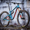
Ibis Cycles
since 2015Sponsor
Flow Trail 1 Details
-
Activities
- Mountain Bike
- Hike
- Trail Running
-
Riding AreaSoquel Demonstration State Forest
Santa Cruz, California -
Difficulty Rating
-
Voted DifficultyBlue (2 votes)
-
Trail TypeSingletrack
-
Bike TypeDH, AM, XC, DJ
-
DirectionDownhill PrimaryPopular direction shown
-
Dogs AllowedYes
-
eBike Allowed
-
Global Ranking
-
Local Popularity95 in Mountain Biking [+]
- 60 in Trail Running
- 70 in Hiking
-
Land Manager
Built specifically for mountain bikes, a flow trail emphasizes speed and rhythm, featuring berms, rollers, jumps and other features that are designed in a way that uses the rider’s momentum to minimize pedaling and braking (think downhill pump track). From the young (or not so young) beginner, to the downhill pro, a flow trail delivers smiles for riders of all ages and skill level.
MBoSC has partnered with land manager California Department of Forestry and Fire Protection (CAL FIRE) to build a four mile flow trail in Soquel Demonstration State Forest (SDSF). The objectives of this project are to promote mountain biking by creating a progressive trail that can be enjoyed by riders of all ages and ability level, and to increase the diversity of riding opportunities, demonstrate innovative and sustainable trail building design and techniques, and provide a model for other land managers for similar types of projects.
Local Trail Association
-
-
Please consider joining or donating to the local trail association to supportdonate to earn trail karma!
trail development & maintenance.
Traditionally Indigenous Territory
More Stats for Flow Trail 1 mountain bike trail trail
-
Altitude change-353 ft
-
Altitude min1,684 ft
-
Altitude max2,037 ft
-
Altitude start2,037 ft
-
Altitude end1,683 ft
-
Grade-7.3%
-
Grade max-34.5%
-
Distance down4,665 ft
-
Distance flat141 ft
-
Avg time00:05:12
-
Avg reverse time00:25:50
- view trail stats
- Unknown
- Snow Groomed
- Snow Packed
- Snow Covered
- Snow Cover Inadequate
- Freeze/thaw Cycle
- Icy
- Prevalent Mud
- Wet
- Variable
- Ideal
- Dry
- Very Dry
The colour categories are based on what percentage of riders are riding a trail in its intended direction.
- > 96%
- > 90%
- > 80%
- > 70%
- > 50%
- < 50%
- bi-directional trail
- no data
- < 2 days
- < 1 week
- < 2 weeks
- < 1 month
- < 6 months
- > 6 months
- Downhill Only
- Downhill Primary
- Both Directions
- Uphill Primary
- Uphill Only
- One Direction
- Description
- Photos
- Description & Photos
- Videos
- most popular
- popular
- less popular
- not popular
- mountain biking recent
- mountain biking (>6 month)
- hiking (1 year)
- moto (1 year)
- Downhill Ski
- Backcountry Ski
- Nordic Ski
Save the current map location and zoom level as your default home location whenever this page is loaded.
SaveFlow Trail 1 Trail Reports
Recent Ridelog Activity on Trail
Past Week
- 44 rides
- 16 miles avg distance
6 Months
- 1,409 rides
- 18 miles avg distance
All
- 11,108 rides

Photos
Trail Lists
-
NorCal Dreamin'
7 trails
-
The Trail One List
7 trails
Routes with this trail
Trail Products
-
 SCMTS MembershipTrail Pass
-
+ 1
 twowheeledwanderer
(Dec 3, 2019 at 11:20)
twowheeledwanderer
(Dec 3, 2019 at 11:20)

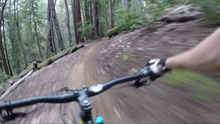
Videos


Nearby Trails
- Braille Dh 761 ft
- Ridge Trail (tractor To Sawpit) 3,028 ft
- Flow Trail 2 3,091 ft
- Logging Spur 3,169 ft
- Flow Trail 3 3,573 ft
Soquel Demonstration State Forest
- embed Flow Trail 1 trail on your website
- By brenthillier
 NSMBA TRAILFORKS & contributors
 - #29328 - 15,710 views
- subscribe
- login to download gpx or kml files.