close
Trail Conditions
- Unknown
- Snow Groomed
- Snow Packed
- Snow Covered
- Snow Cover Inadequate
- Freeze/thaw Cycle
- Icy
- Prevalent Mud
- Wet
- Variable
- Ideal
- Dry
- Very Dry
Trail Flow (Ridden Direction)
Trailforks scans users ridelogs to determine the most popular direction each trail is ridden. A good flowing trail network will have most trails flowing in a single direction according to their intension.
The colour categories are based on what percentage of riders are riding a trail in its intended direction.
The colour categories are based on what percentage of riders are riding a trail in its intended direction.
- > 96%
- > 90%
- > 80%
- > 70%
- > 50%
- < 50%
- bi-directional trail
- no data
Trail Last Ridden
Trailforks scans ridelogs to determine the last time a trail was ridden.
- < 2 days
- < 1 week
- < 2 weeks
- < 1 month
- < 6 months
- > 6 months
Trail Ridden Direction
The intended direction a trail should be ridden.
- Downhill Only
- Downhill Primary
- Both Directions
- Uphill Primary
- Uphill Only
- One Direction
Contribute Details
Colors indicate trail is missing specified detail.
- Description
- Photos
- Description & Photos
- Videos
Trail Popularity ?
Trailforks scans ridelogs to determine which trails are ridden the most in the last 9 months.
Trails are compared with nearby trails in the same city region with a possible 25 colour shades.
Think of this as a heatmap, more rides = more kinetic energy = warmer colors.
- most popular
- popular
- less popular
- not popular
ATV/ORV/OHV Filter
Max Vehicle Width
inches
Radar Time
x
Activity Recordings
Trailforks users anonymized public ridelogs from the past 6 months.
- mountain biking recent
- mountain biking (>6 month)
- hiking (1 year)
- moto (1 year)
Activity Recordings
Trailforks users anonymized public skilogs from the past 12 months.
- Downhill Ski
- Backcountry Ski
- Nordic Ski
Jump Magnitude Heatmap
Heatmap of where riders jump on trails. Zoom in to see individual jumps, click circles to view jump details.
Trails Deemphasized
Trails are shown in grey.
Only show trails with NO bikes.
Save the current map location and zoom level as your default home location whenever this page is loaded.
SaveEdmonton’s River Valley is the largest urban park in North America. We may not have any mountains, but our singletrack network is extensive. A little bit of local knowledge and route finding is key to linking our short but sweet trails into epic rides. Hidden gems are everywhere if you know where to look.
Activities Click to view
- Mountain Bike
966 trails
- E-Bike
251 trails
- Hike
947 trails
- Trail Running
944 trails
- Horse
2 trails
- ATV/ORV/OHV
0 trails
- Snowshoe
13 trails
- Downhill Ski
16 trails
- Nordic Ski
20 trails
Region Details
- 291
- 111
- 193
- 277
- 79
- 13
Region Status
Open as of Apr 7, 2021Stats
- Avg Trail Rating
- Trails (view details)
- 1,011
- Trails Mountain Bike
- 966
- Trails E-Bike
- 251
- Trails Hike
- 947
- Trails Trail Running
- 944
- Trails Horse
- 2
- Trails Snowshoe
- 13
- Trails Downhill Ski
- 16
- Trails Backcountry Ski
- 3
- Trails Nordic Ski
- 20
- Total Distance
- 415 miles
- Total Descent
- 35,606 ft
- Total Vertical
- 530 ft
- Highest Trailhead
- 2,523 ft
- Reports
- 27,376
- Photos
- 3,180
- Ridden Counter
- 384,704
Sub Regions
-
Buena Vista
- 1
- 4
- 4
- 1
-
Bulyea Trails
- 1
- 4
- 4
-
Central Edmonton (North)
- 3
- 4
- 7
-
Central Edmonton (South)
- 13
- 13
- 58
- 6
-
Elk Island National Park
-
Forest Heights
- 3
- 2
- 18
- 5
- 2
-
Gold Bar/Capilano Park
- 5
- 10
- 3
- 1
-
Hawrelak
- 4
- 5
- 11
- 5
- 4
-
Keillor
- 2
- 11
- 11
- 11
-
Kinnaird Park
- 2
- 3
- 15
- 3
-
Mill Creek Ravine
- 12
- 12
- 31
- 13
- 3
-
Mill Woods
- 20
- 23
- 19
- 1
-
North East Edmonton
- 7
- 2
-
Rundle Park
- 4
- 1
-
South Edmonton
- 1
- 2
-
South West Edmonton
-
Strathcona Science Provincial Park
- 8
- 5
- 24
- 5
- 1
-
Terwillegar
- 11
- 49
- 34
- 11
-
Westpointe Ravine
- 8
- 12
- 1
-
Whitemud
- 2
- 9
- 3
- 4
Popular Edmonton Mountain Biking Trails
Edmonton Mountain Bike Routes
| title | rating | distance |
|---|---|---|
| YEG Epic | 25 miles | |
| H2H (2018) - Black | 26 miles | |
| Patricia Ravine Route | 21 miles | |
| Mill Creek MTB Route | 11 miles | |
| Bladed Raven | 1 mile | |
| Shaw Conference, Kingsmen, Rundle, Terwillegar, Fox Trail Loop | 24 miles | |
| Capilano Gold Bar East Loop to Caddyshack and Back | 9 miles | |
| McNally Shredders Loop 1 | 5 miles | |
| Hawerlak Park ROute | 7 miles | |
| Shredders Kinsmen Loop #1 | 6 miles |
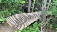
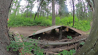
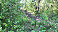
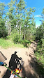
Photos of Edmonton Mountain Bike
trail: Selkirk Knights
124 |
Oct 5, 2020 @ 8:57pm
Oct 5, 2020
trail: Hustler
409 |
Oct 17, 2018 @ 4:32pm
Oct 17, 2018
trail: GO Trail
580 | | 1 comments
Apr 18, 2016 @ 8:09am
Apr 18, 2016
trail: 780-Flow
524 | | 1 comments
Apr 14, 2016 @ 10:03pm
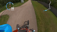
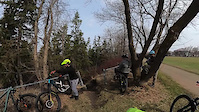
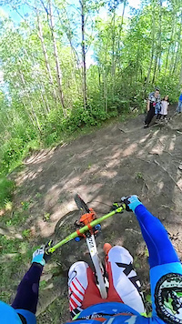
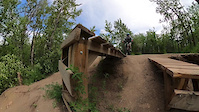
Apr 14, 2016Videos of Edmonton Mountain Bike
trail: Two Garths
8 |
Jul 2, 2022
trail: MooseKnuckle
12 |
Jul 2, 2022
trail: Two Garths
8 |
Jul 1, 2022
trail: Short and Sweet
13 |
Jun 21, 2022
trail: I AM gROOT
21 |
Jun 15, 2022
trail: I AM gROOT
10 |
Jun 15, 2022
trail: I AM gROOT
24 |
Jun 15, 2022
trail: Curvin Murvin
22 |
Jun 13, 2022
Current Trail Warnings
| status | trail | date | condition | user | info |
|---|---|---|---|---|---|
| Slinky - South | Jul 4, 2022 @ 8:38am 2 days | Wet | MustafaQI6C82 | Underwater. | |
| Ridge Runner | Jul 3, 2022 @ 9:35pm 2 days | Prevalent Mud | millcreekmtb | huge mud hole in the usual spot | |
| Argyll Singletrack | Jul 3, 2022 @ 9:22pm 2 days | Ideal | millcreekmtb | very erroded |
Recent Trail Reports
| status | trail | date | condition | info | user |
|---|---|---|---|---|---|
| Fort Edmonton Connector | Jul 4, 2022 @ 6:36pm 1 day | Ideal | irmalcol | ||
| Oleskiw Access | Jul 4, 2022 @ 6:36pm 1 day | Ideal | irmalcol | ||
| Terwillegar Park Footbridge | Jul 4, 2022 @ 6:36pm 1 day | Ideal | irmalcol | ||
| John Jantzen Path | Jul 4, 2022 @ 6:36pm 1 day | Ideal | irmalcol | ||
| Keilor Road | Jul 4, 2022 @ 6:36pm 1 day | Ideal | irmalcol | ||
| Saskatchewan Dr Access South | Jul 4, 2022 @ 6:36pm 1 day | Ideal | irmalcol | ||
| Farm Frolic | Jul 4, 2022 @ 4:15pm 1 day | Variable | dustinmcl | ||
| Because you can't | Jul 4, 2022 @ 4:15pm 1 day | Ideal | dustinmcl | ||
| Slinky - Mid | Jul 4, 2022 @ 4:15pm 1 day | Variable | dustinmcl | ||
| Under the End | Jul 4, 2022 @ 4:15pm 1 day | Ideal | dustinmcl |
Activity Feed
| username | action | type | title | date | |
|---|---|---|---|---|---|
 | cbijelic | wishlist | route | Hawerlak Park ROute | Jul 6, 2022 @ 1:03am 3 hours |
| cbijelic | wishlist | route | Patricia Ravine Route | Jul 6, 2022 @ 1:00am 3 hours |
 | boyblue1973 | wishlist | route | RVR Winter Portion - Flagged | Jul 5, 2022 @ 12:32pm 15 hours |
| myawo | wishlist | trail | GO Trail | Jul 5, 2022 @ 10:39am 17 hours |
| myawo | wishlist | trail | Two Garths and 1 more | Jul 5, 2022 @ 10:37am 17 hours |
Recent Comments
| username | type | title | comment | date | |
|---|---|---|---|---|---|
| report | Very wet and muddy now | Jun 23, 2022 @ 4:36pm Jun 23, 2022 | ||
| report | Well it's all mud now LOL | Jun 23, 2022 @ 4:36pm Jun 23, 2022 | ||
| trail | Lol, small drop for riders that hit it well... | Jun 22, 2022 @ 2:59pm Jun 22, 2022 | ||
| trail | Quite mucky after recent rains (June, 2022).... | Jun 19, 2022 @ 8:31am Jun 19, 2022 | ||
| trail | wicked trail! either flowy line or gnarly root... | Jun 15, 2022 @ 10:21am Jun 15, 2022 |
Local Badges
-

Big Ride 30k12,808 awarded -

10 Blue Trails1,540 awarded -

10 Green Trails1,263 awarded -

10 Black Trails618 awarded -

Climbing 10k Badge462 awarded -

Top 10 Trails69 awarded
Bike & Skill Parks
| name | type | city | rating |
|---|---|---|---|
| Callingwood Skate Plaza | skill park | Edmonton | |
| Capilano Skatepark | skill park | Edmonton | |
| Kaskitayo Skatepark | skill park | Edmonton | |
| Kenilworth Skills Park | skill park | Edmonton | |
| Mckernan Skatepark | skill park | Edmonton |
Activity Type Stats
| activitytype | trails | distance | descent | descent distance | total vertical | rating | global rank | state rank | photos | reports | routes | ridelogs |
|---|---|---|---|---|---|---|---|---|---|---|---|---|
| Mountain Bike | 966 | 387 miles | 32,215 ft | 144 miles | 531 ft | #5 | #1 | 3,138 | 27,273 | 87 | 157,881 | |
| E-Bike | 251 | 112 miles | 6,860 ft | 37 miles | 420 ft | #28 | #2 | 2 | 22,798 | 6 | 1,113 | |
| Hike | 947 | 390 miles | 32,283 ft | 145 miles | 531 ft | #3 | #1 | 16 | 27,110 | 5 | 2,319 | |
| Trail Running | 944 | 389 miles | 32,247 ft | 144 miles | 531 ft | #3 | #1 | 15 | 27,113 | 17 | 17,759 | |
| Horse | 2 | 2 miles | 46 ft | 3,734 ft | 217 ft | #13 | 9,888 | 11 | ||||
| Snowshoe | 13 | 5 miles | 361 ft | 2 miles | 223 ft | #115 | #6 | 72 | 196 | |||
| Downhill Ski | 16 | 3 miles | 1,503 ft | 2 miles | 213 ft | #12 | #1 | 4 | 124 | 328 | ||
| Backcountry Ski | 3 | 2 miles | 52 ft | 3,438 ft | 72 ft | 29 | 1 | 18 | ||||
| Nordic Ski | 20 | 19 miles | 1,043 ft | 7 miles | 177 ft | #9 | 94 | 1 | 2,374 |
- By OldDad & contributors
- Admins: AEF, warrenmacdonald, EMBA, EdmontonMountainBikeAlliance, jdd4, yegmtb1
- #4284 - 286,386 views
- edmonton activity log | embed map of Edmonton mountain bike trails | edmonton mountain biking points of interest polygons
Downloading of trail gps tracks in kml & gpx formats is enabled for Edmonton.
You must login to download files.