5.7 miles
Distance
993 ft
Climb
-990 ft
Descent
1 mile
High Point
A great ride to start the season. Can be done under an hour.
Detailed Description
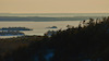
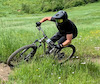
Ranger Summit to Strange Brew is a 6 mile popular intermediate route located near Bragg Creek Alberta. This mountain bike primary route can be used one direction and has a moderate overall physical rating. This route includes 5 trails. This route climbs 993 ft with a max elevation of 5,594 ft then descends -990 ft.
Local Trail Association

Please consider joining or donating to the local riding association to support trail development & maintenance.
donate to earn trail karma!
-
+ 0
Brukalski
 (Jun 9, 2022 at 21:13)
Trail Ranger Summit
Good condition, couple stops but good climb
[Reply]
 mantistoboggan939
Trail Strange Brew
Fun fast trail, flows very well for the majority after the small climb a quarter way in. Many potential natural gaps
[Reply]
mantistoboggan939
Trail Strange Brew
Fun fast trail, flows very well for the majority after the small climb a quarter way in. Many potential natural gaps
[Reply]
 Jasongyip
Trail Ranger Summit
In pretty good condition today. Some fresh snow at the top. Fun climb!
[Reply]
 whisky
Trail Strange Brew
Nice and grippy but, full of horse tracks that make for a bumpy, slow, uncomfortable start to decent. ~2-4 km ?
[Reply]
whisky
Trail Strange Brew
Nice and grippy but, full of horse tracks that make for a bumpy, slow, uncomfortable start to decent. ~2-4 km ?
[Reply]
whisky
Trail Ranger Summit
Jan 2, morning
Snow too soft. Constant momentum interruptions by hikers or coming to a halt on 3/4 of the hills due to sinking or being pulled into ruts.
Best to stick to low elevations this week with the warmer temps.
[Reply]
Snow too soft. Constant momentum interruptions by hikers or coming to a halt on 3/4 of the hills due to sinking or being pulled into ruts.
Best to stick to low elevations this week with the warmer temps.
Gonnad
(Jul 26, 2020 at 7:52)
Trail Ranger Summit
If you want a quieter ride at the weekend use the trails to the south of the carpark. Rangers Summit yesterday was dry and in good condition.
[Reply]
Gonnad
(Jul 26, 2020 at 7:46)
Trail Strange Brew
I did this yesterday. If you like roots and rocks this is the one for you, recommend going up Rangers and down Strange Brew. A few muddy patches but in good condition.
[Reply]
Gonnad
(Jul 26, 2020 at 7:46)
Trail Strange Brew
I did this yesterday. If you like roots and rocks this is the one for you, recommend going up Rangers and down Strange Brew. A few muddy patches but in good condition.
[Reply]
Davidbopp
(May 25, 2020 at 6:46)
Trail Boundary Ridge
Lots of mud. Not possible to ride without damaging the trail.
[Reply]
Davidbopp
(May 25, 2020 at 6:46)
Trail Boundary Ridge
Lots of mud. Not possible to ride without damaging the trail.
[Reply]
 agiard
(Oct 25, 2019 at 5:41)
agiard
(Oct 25, 2019 at 5:41)
Trail Ranger Summit
Icy patches for the first km then it clears up nicely.
[Reply]
Lopht
(Sep 1, 2019 at 17:06)
Trail Ranger Summit
Little wet Sep 1. Nice easy consistent climb
[Reply]
Jugheed
(May 14, 2019 at 21:15)
Trail Strange Brew
May 14, Trail is in pretty good shape.
Unfortunately can’t say the same for the Baruch’s Corner sign at the top lookout, and the trail-map at the Elbow junction. Somebody thinks that wrecking the signs is fun or something.
Anyway, let’s respect what has been provided for the enjoyment of the area without ruining it for everybody.
[Reply]
Unfortunately can’t say the same for the Baruch’s Corner sign at the top lookout, and the trail-map at the Elbow junction. Somebody thinks that wrecking the signs is fun or something.
Anyway, let’s respect what has been provided for the enjoyment of the area without ruining it for everybody.
 MarkruShredding
Trail Ranger Summit
Sept 24 trail in good condition but wet and greasy in many areas.
[Reply]
Lenniee
(Jul 10, 2018 at 14:24)
Trail Boundary Ridge
Bad trail fell off so many times needs a new everything I rate it 1/10
[Reply]
Lenniee
(Jul 10, 2018 at 14:24)
Trail Boundary Ridge
Bad trail fell off so many times needs a new everything I rate it 1/10
[Reply]
rcaughlin
(Aug 18, 2017 at 5:16)
Trail Ranger Summit
Long climb that doesn't stop until the top.
[Reply]
EVdad
(Apr 12, 2015 at 7:22)
Trail Boundary Ridge
Trail mostly damp with occasional muddy patches and many dry areas.
[Reply]
EVdad
(Apr 12, 2015 at 7:22)
Trail Boundary Ridge
Trail mostly damp with occasional muddy patches and many dry areas.
[Reply]
Trails in Route
| 2 miles | |||||
| 2 miles | |||||
| 4,426 ft |
Details
-
Riding area
-
Primary ActivityMountain Bike
-
Other Activities
- E-Bike
-
Difficulty ratingBlue
-
Route TypeLoop
-
eBike Allowed
-
Bike typeAM, XC, Fat
-
DirectionOne Direction
-
Physical ratingModerate
-
Ridelogs
More Stats for Ranger Summit to Strange Brew mountain bike route
-
Altitude min4,639 ft
-
Altitude start4,639 ft
-
Altitude end4,642 ft
-
Grade max-46.3%
-
Grade min29.7%
-
Distance climb3 miles
-
Distance down3 miles
-
Distance flat1,450 ft
close
Trail Conditions
- Unknown
- Snow Groomed
- Snow Packed
- Snow Covered
- Snow Cover Inadequate
- Freeze/thaw Cycle
- Icy
- Prevalent Mud
- Wet
- Variable
- Ideal
- Dry
- Very Dry
Trail Flow (Ridden Direction)
Trailforks scans users ridelogs to determine the most popular direction each trail is ridden. A good flowing trail network will have most trails flowing in a single direction according to their intension.
The colour categories are based on what percentage of riders are riding a trail in its intended direction.
The colour categories are based on what percentage of riders are riding a trail in its intended direction.
- > 96%
- > 90%
- > 80%
- > 70%
- > 50%
- < 50%
- bi-directional trail
- no data
Trail Last Ridden
Trailforks scans ridelogs to determine the last time a trail was ridden.
- < 2 days
- < 1 week
- < 2 weeks
- < 1 month
- < 6 months
- > 6 months
Trail Ridden Direction
The intended direction a trail should be ridden.
- Downhill Only
- Downhill Primary
- Both Directions
- Uphill Primary
- Uphill Only
- One Direction
Contribute Details
Colors indicate trail is missing specified detail.
- Description
- Photos
- Description & Photos
- Videos
Trail Popularity ?
Trailforks scans ridelogs to determine which trails are ridden the most in the last 9 months.
Trails are compared with nearby trails in the same city region with a possible 25 colour shades.
Think of this as a heatmap, more rides = more kinetic energy = warmer colors.
- most popular
- popular
- less popular
- not popular
ATV/ORV/OHV Filter
Max Vehicle Width
inches
Radar Time
x
Activity Recordings
Trailforks users anonymized public ridelogs from the past 6 months.
- mountain biking recent
- mountain biking (>6 month)
- hiking (1 year)
- moto (1 year)
Activity Recordings
Trailforks users anonymized public skilogs from the past 12 months.
- Downhill Ski
- Backcountry Ski
- Nordic Ski
Jump Magnitude Heatmap
Heatmap of where riders jump on trails. Zoom in to see individual jumps, click circles to view jump details.
Trails Deemphasized
Trails are shown in grey.
Only show trails with NO bikes.
Save the current map location and zoom level as your default home location whenever this page is loaded.
Save
Trail transparency
Photos
Videos


360 camera view. Ranger Summit, W. Bragg Creek
trail: Ranger Summit
16:43 | 347 | comments: 0 | favs:
Oct 10, 2020
Recent Trail Reports Along Route
more reports »
- By markryall & contributors
- #7058 - 5,472 views
- login to download gpx or kml files.