close
Trail Conditions
- Unknown
- Snow Groomed
- Snow Packed
- Snow Covered
- Snow Cover Inadequate
- Freeze/thaw Cycle
- Icy
- Prevalent Mud
- Wet
- Variable
- Ideal
- Dry
- Very Dry
Trail Flow (Ridden Direction)
Trailforks scans users ridelogs to determine the most popular direction each trail is ridden. A good flowing trail network will have most trails flowing in a single direction according to their intension.
The colour categories are based on what percentage of riders are riding a trail in its intended direction.
The colour categories are based on what percentage of riders are riding a trail in its intended direction.
- > 96%
- > 90%
- > 80%
- > 70%
- > 50%
- < 50%
- bi-directional trail
- no data
Trail Last Ridden
Trailforks scans ridelogs to determine the last time a trail was ridden.
- < 2 days
- < 1 week
- < 2 weeks
- < 1 month
- < 6 months
- > 6 months
Trail Ridden Direction
The intended direction a trail should be ridden.
- Downhill Only
- Downhill Primary
- Both Directions
- Uphill Primary
- Uphill Only
- One Direction
Contribute Details
Colors indicate trail is missing specified detail.
- Description
- Photos
- Description & Photos
- Videos
Trail Popularity ?
Trailforks scans ridelogs to determine which trails are ridden the most in the last 9 months.
Trails are compared with nearby trails in the same city region with a possible 25 colour shades.
Think of this as a heatmap, more rides = more kinetic energy = warmer colors.
- most popular
- popular
- less popular
- not popular
ATV/ORV/OHV Filter
Max Vehicle Width
inches
Radar Time
x
Activity Recordings
Trailforks users anonymized public ridelogs from the past 6 months.
- mountain biking recent
- mountain biking (>6 month)
- hiking (1 year)
- moto (1 year)
Activity Recordings
Trailforks users anonymized public skilogs from the past 12 months.
- Downhill Ski
- Backcountry Ski
- Nordic Ski
Jump Magnitude Heatmap
Heatmap of where riders jump on trails. Zoom in to see individual jumps, click circles to view jump details.
Trails Deemphasized
Trails are shown in grey.
Only show trails with NO bikes.
Save the current map location and zoom level as your default home location whenever this page is loaded.
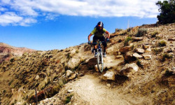
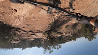
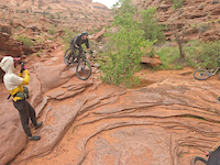
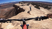
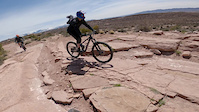
SaveHome of the original Slickrock and Upper Porcupine Singletrack Mountain Bike Trails, Moab has been the ultimate mountain bikers road trip destination for years. If coming from the north Klondike Bluffs is an excellent start, and will provide some very easy kid friendly trainer trails along with some medium level trails to get even seasoned experts warmed up. The Gemini Bridges area is usually my next target trail system hosting the Magnificent 7 (aka Mag 7) which will also connect to Gold Bar Rim. Head into town and over to Kane Creek to access the more expert level trails, with Captain Ahab and the Amasa Back area being the local favorites. Every year new mountain bike trails and trail systems are added, and the town offers a lively nightlife.
Activities Click to view
- Mountain Bike
425 trails
- E-Bike
132 trails
- Hike
542 trails
- Trail Running
530 trails
- Horse
34 trails
- Dirtbike/Moto
107 trails
- ATV/ORV/OHV
80 trails
- Snowshoe
2 trails
- Backcountry Ski
2 trails
- Nordic Ski
0 trails
Region Details
- 134
- 9
- 52
- 139
- 71
- 18
- 2
Region Status
Open as of May 21, 2022Local Trail Association
Stats
- Avg Trail Rating
- Trails (view details)
- 529
- Trails Mountain Bike
- 425
- Trails E-Bike
- 132
- Trails Hike
- 543
- Trails Trail Running
- 530
- Trails Horse
- 34
- Trails Dirtbike/Moto
- 107
- Trails Observed Trials
- 4
- Trails ATV/ORV/OHV
- 80
- Trails Snowshoe
- 2
- Trails Downhill Ski
- 2
- Trails Backcountry Ski
- 2
- Total Distance
- 1,089 mile
- Total Descent
- 163,502 ft
- Total Vertical
- 8,692 ft
- Highest Trailhead
- 12,607 ft
- Reports
- 6,910
- Photos
- 3,813
- Ridden Counter
- 283,797
 Articles
Registration Opens For 2022 BetterRide Skills Courses
Dec 29, 2021 from pinkbike.com
Three-day coaching courses in Nevada, Colorado, Utah, Arizona, and more.
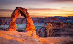
Heads Up: You'll Need a Reservation to Get Into Arches National Park in 2022
Dec 10, 2021 from backpacker.com
Starting in April, visitors will need a timed entry ticket to get entry to Arches.
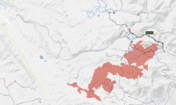
Moab's Whole Enchilada Trail Closed by Pack Creek Fire
Jun 15, 2021 from pinkbike.com
We wish the wildfire fighters battling the blaze the best of luck.
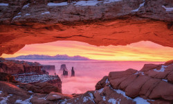
Hike of the Week: Mesa Arch Trail, Moab, UT
Jan 14, 2019 from backpacker.com
Get a new perspective on an iconic view when you hike to Canyonlands National Park's famous Mesa Arch in winter.
Sub Regions
-
Amasa Back
- 2
- 3
- 7
- 5
-
Arches National Park
- 1
- 1
-
Canyonlands National Park - Island in the Sky
- 2
-
Dead Horse Point
- 4
- 6
-
Horsethief
- 6
- 10
-
Klondike Bluffs
- 11
- 15
- 13
-
Klonzo
- 11
- 16
- 4
-
La Sal Mountains
- 1
- 22
- 17
- 2
- 1
-
Mag 7
- 2
- 10
- 3
- 3
- 1
-
Moab Brand Trails
- 9
- 10
- 4
- 1
-
Navajo Rocks
- 7
-
Sand Flats Recreation Area
- 1
- 12
- 4
- 1
-
Sovereign Trail System
- 1
- 6
- 9
- 3
Popular Moab Mountain Biking Trails
Moab Mountain Bike Routes
| title | rating | distance |
|---|---|---|
| Brand to Klonzo Ultimate | 20 miles | |
| The Whole Enchilada - Moab, Utah | 27 miles | |
| Hymasa/Captain Ahab loop | 8 miles | |
| Always End on a Down Hill-Longer | 18 miles | |
| Navajo Rocks Loop! | 17 miles | |
| Navajo Rocks full loop | 17 miles | |
| Falcon Flow Sand Flats Road Loop | 8 miles | |
| Eagle Eye to Falcon Flow - The Raptor Route | 10 miles | |
| LPS to Porcupine Rim | 14 miles | |
| 3/4 Enchilada - Starting on Hazard County at Miners Basin parking - RideSpots.com | 20 miles |
Photos of Moab Mountain Bike
trail: TWE Beginning
1,271 |
Jan 21, 2018 @ 2:14pm
Jan 21, 2018
trail: Slickrock
1,256 |
Jan 19, 2018 @ 2:04pm
Jan 19, 2018
trail: Porcupine Rim
3,106 |
Jan 19, 2018 @ 2:03pm
Jan 19, 2018
trail: Great Escape
654 |
Jan 19, 2018 @ 2:03pm
Jan 19, 2018
trail: Captain Ahab (lower)
1,277 |
Jan 19, 2018 @ 2:01pm
Jan 19, 2018
trail: Pothole Arch
164 |
Jan 7, 2018 @ 12:14pm
Jan 7, 2018
trail: Porcupine Rim
1,076 |
Jan 7, 2018 @ 12:06pm
Jan 7, 2018
trail: UPS Lower
322 |
Dec 2, 2017 @ 11:23pm
Dec 2, 2017Videos of Moab Mountain Bike
trail: Bull Run
47 |
May 7, 2022
80 |
May 4, 2022
trail: Portal
110 |
Apr 19, 2022
trail: Porcupine Rim
102 |
Apr 16, 2022
trail: LPS
|
Apr 12, 2022
trail: Captain Ahab (lower)
104 |
Mar 26, 2022

trail: UPS
231 |
Nov 18, 2021

trail: UPS
|
Nov 18, 2021
Recent Trail Reports
| status | trail | date | condition | info | user |
|---|---|---|---|---|---|
| Jimmy Keen (E) | May 16, 2022 @ 4:33pm May 16, 2022 | Ideal | GrandCountyTrails MTM | ||
| Jimmy Keen Return | May 16, 2022 @ 4:33pm May 16, 2022 | Ideal | GrandCountyTrails MTM | ||
| Lower Jimmy Keen | May 16, 2022 @ 4:30pm May 16, 2022 | Ideal | GrandCountyTrails MTM | ||
| Warner To Oowah (030) | May 16, 2022 @ 4:29pm May 16, 2022 | Dry | GrandCountyTrails MTM | ||
| Warner Lake Road | May 16, 2022 @ 4:28pm May 16, 2022 | Dry | GrandCountyTrails MTM | ||
| Mustang West | Feb 11, 2022 @ 11:53am Feb 11, 2022 | Prevalent Mud | GrandCountyTrails MTM | ||
| Seven Mile Flat | Jan 10, 2022 @ 9:41am Jan 10, 2022 | Prevalent Mud | MoabTrailMix MTM | ||
| Sidewinder Access | Jan 10, 2022 @ 9:41am Jan 10, 2022 | Prevalent Mud | MoabTrailMix MTM | ||
| Deadmans Conn | Jan 10, 2022 @ 9:41am Jan 10, 2022 | Prevalent Mud | MoabTrailMix MTM | ||
| Ez Access | Jan 10, 2022 @ 9:41am Jan 10, 2022 | Prevalent Mud | MoabTrailMix MTM |
Activity Feed
| username | action | type | title | date | |
|---|---|---|---|---|---|
 | PeterXbmHVq | wishlist | region | Mag 7 | Jul 5, 2022 @ 9:42pm 4 hours |
 | Robtraina | wishlist | route | The Whole Enchilada - Moab, Utah | Jul 5, 2022 @ 5:08pm 9 hours |
 | christoonic | wishlist | route | The Whole Enchilada - Moab, Utah | Jul 5, 2022 @ 2:54pm 11 hours |
| iDuraz | wishlist | route | Eagle Eye - Falcon Flow and 2 more | Jul 5, 2022 @ 8:46am 17 hours |
| Nmhinton | vote | trail | Pipe Dream | Jul 5, 2022 @ 5:01am 21 hours |
Recent Comments
| username | type | title | comment | date | |
|---|---|---|---|---|---|
 | trail | Took this trail from Hazzard County TH and... | Jun 27, 2022 @ 7:42am Jun 27, 2022 | ||
| trail | Shuttled here with Rim Tours and | Jun 27, 2022 @ 7:37am Jun 27, 2022 | ||
| trail | Great fast ride. Pick your line | Jun 27, 2022 @ 7:23am Jun 27, 2022 | ||
| trail | Good Intermediate trail, has a little bit of... | Jun 26, 2022 @ 8:58am Jun 26, 2022 | ||
| trail | One of the most fun sections in the Klondike... | Jun 20, 2022 @ 10:58pm Jun 20, 2022 |
Local Badges
-

Big Ride 30k11,838 awarded -

10 Black Trails1,799 awarded -

Epic Ride 50k2,876 awarded -

Top 10 Trails705 awarded -

10 Green Trails607 awarded -

10 Blue Trails2,367 awarded
Bike & Skill Parks
| name | type | city | rating |
|---|---|---|---|
| Moab BMX Park | skill park | Moab |
Upcoming Local Events
Activity Type Stats
| activitytype | trails | distance | descent | descent distance | total vertical | rating | global rank | state rank | photos | reports | routes | ridelogs |
|---|---|---|---|---|---|---|---|---|---|---|---|---|
| Mountain Bike | 425 | 950 miles | 132,503 ft | 436 miles | 7,251 ft | #8 | #4 | 3,575 | 6,864 | 105 | 83,860 | |
| E-Bike | 132 | 419 miles | 41,673 ft | 179 miles | 6,096 ft | #54 | #12 | 4 | 6,050 | 4 | 837 | |
| Hike | 542 | 1,089 mile | 163,468 ft | 495 miles | 8,691 ft | #5 | #2 | 203 | 6,871 | 80 | 7,133 | |
| Trail Running | 530 | 1,077 mile | 160,810 ft | 489 miles | 8,691 ft | #5 | #2 | 14 | 6,871 | 90 | 921 | |
| Horse | 34 | 122 miles | 12,405 ft | 45 miles | 8,629 ft | #297 | #173 | 3,212 | 2 | 3 | ||
| Dirtbike/Moto | 107 | 302 miles | 32,336 ft | 115 miles | 6,073 ft | #1 | #1 | 4 | 3,274 | 2 | 177 | |
| Observed Trials | 4 | 16 miles | 942 ft | 3 miles | 5,390 ft | 2 | 14 | |||||
| ATV/ORV/OHV | 80 | 296 miles | 29,068 ft | 114 miles | 6,076 ft | #10 | #5 | 13 | 3,279 | 119 | ||
| Snowshoe | 2 | #277 | 587 | 11 | ||||||||
| Downhill Ski | 2 | 77 | 16 | |||||||||
| Backcountry Ski | 2 | #292 | 587 | 39 |
- By brenthillier
 NSMBA TRAILFORKS & contributors
 - Admins: UtahJohn, jpmcghee, jasonmalczyk, MTM, MMBA, GrandCountyTrails
- #3495 - 142,296 views
- moab activity log | embed map of Moab mountain bike trails | moab mountain biking points of interest polygons
Downloading of trail gps tracks in kml & gpx formats is disabled for Moab.